From Puerto Natales to Punta Arenas – we’ve been detailing our moves to the south, and our next stop is the most south we’ll ever go – Puerto Williams, on Isla Navarino in Chile.
There’s not much to Puerto Williams. Being at a tiny town so close to Antarctica has a real charm, but we travelled there for one reason – the hike at the end of the world, the Dientes de Navarino.
The trail is named for the mountainous prominence the circuit winds around, which look a lot like – well – teeth. If you fly into Puerto Williams, you’ll probably be able to see them out your windows. They really are an impressive rocky feature, like stone canines protruding from mountain gums. The best views (and photo opportunities) are on day one, as you initially climb up into the range but there is plenty to see on the track that will make your own jaw drop!
Click here to take you to ‘Short and Sweet’ that summarises this blog post!
Tell me everything:
Getting There:
Being the end of the world Puerto Williams is not the cheapest or easiest place to arrive in. There’s three ways in and out:
Ferry from Punta Arenas: a 30 hour trip through Patagonia fjords. Apparently, one of the most gorgeous trips you can take, even if the sleeping conditions are questionable.
Fly from Punta Arenas: the quicker option and for a similar price, but you miss out on the experience of the ferry. We did this, and wished we’d taken the ferry!
Ferry from Ushuaia: this is the only way to get to Ushuaia from Puerto Williams, but it is so expensive – 320USD for the ride!
Generally, whichever method you take, your accomodation should offer to pick you up. Puerto Williams is tiny and tourism not a core industry, so the airbnb and hostels are pretty kind.
Accommodation
We stayed with Luis, at his airbnb cabin – it would be at least 40 minutes walking from the town, but it is only ten minutes from the beginning of the Dientes track. We don’t usually comment on where to stay, but we would highly recommend this accomodation – it’s super cute, quiet and an amazing way to disconnect. The family is incredibly lovely, and a friendly homestay lives out the back, too. If we ever found ourselves down that way again we’d stay there in a heartbeat.
The Hike
The Dientes actually has reasonable information on Wikiloc, and the trail is reasonably well marked for the most part. A GPS is still necessary – some sections are confusing and, this part of the world gets a lot of rain so there’s also a lot of bog. Also, clearly, it’s very close to Antarctica – so while not all the track is what would usually be considered ‘alpine’, the weather is incredibly changeable. The passes can snow up and be impassable all year around. If you have the flexibility, arrange to be in Puerto Williams for additional days, and certainly take an extra days’ food and extra dry food, in case you get stuck in your tent. In saying that, the weather forecast should be reasonably accurate – just be prepared that you may arrive and not be able to start in the first place!
The Dientes de Navarino track itself is not very long. The days are around 10km on average. The beauty of the track is in the scenery and the wildness, and being one of the southernmost people in the world. The challenge is in the isolation. You could do it in three days sure – but why would you? You’ll probably never be so far south again, so enjoy the seclusion!
Day 1: Puerto Williams – Laguna Del Salto; 11km, 6-7 hours
The track starts as a day hike, climbing up with switchbacks through forest to Cerro Bandera. There are multiple viewpoints along the way, but the view at the summit is the most spectacular. Treat yourself to the view of Tierra del Fuego. The track then continues along the side of the ridge and towards the Dientes de Navarino. Coming around the ridge you’ll get awesome shots of the Dientes and lakes and rivers below. This is actually the view that our logo is taken from! Eventually, you’ll descend to a lake below the Dientes, where the first campsite is located. All along this route, the campsites are clear with people having set up stick or stone walls to give the tents some shelter.
There is an alternative route into this location, alongside the river, if the winds are too high to walk to Cerro Bandera. We believe some people also walk this as an overnighter loop. There was certainly a large group on the day we stayed at this campsite, and we didn’t see them again.
Day 2: Laguna Del Salto- Laguna Escondida; 9km, 5-6 hours
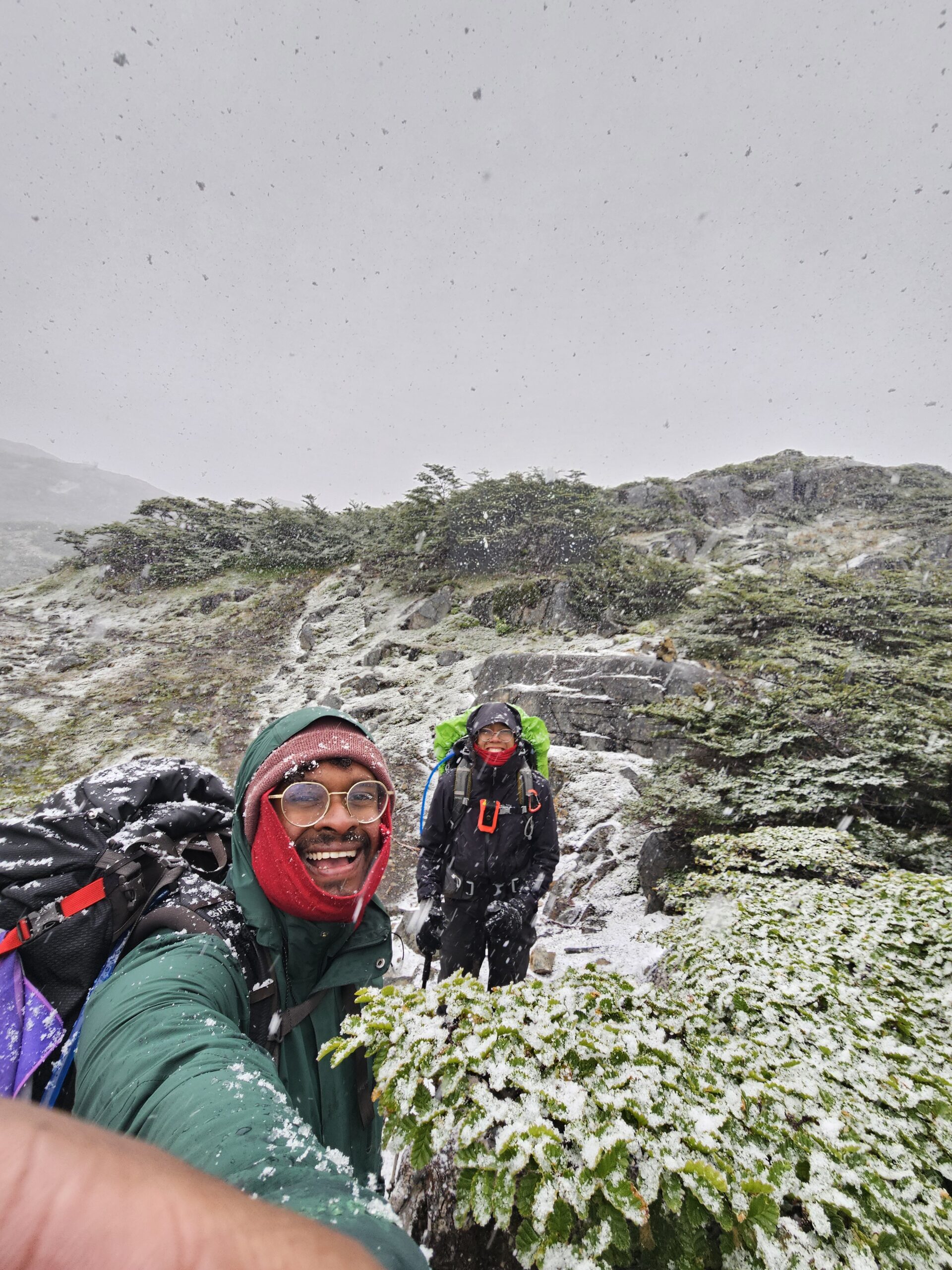
Where day 1 was all great views and chill walking, day 2 was a shitty slog for us. It started raining at about 8am and didn’t let up until the next day. Day 2 is where you should get even better views of the Dientes, as you pass underneath them and through the mountain pass. We didn’t see anything – to be honest, we can hardly recount the track, except that there was a lot of up to start, and a bit of slippery boulder clambering next to a lake. The campsite on the map is pretty nice, situation by a laguna with a great view (we saw in the morning), but we continued onto the other side of the laguna to get a little more privacy – we knew there were quite a few other hikers behind us!
This was a day we were so glad for our tent setup – we can put the footprint and fly up, then sit in the shelter and dry off before putting the inner up. Awal almost got too cold, but our setup meant that everything important stayed dry. The rain did not stop, so it was a cold bread & cheese dinner for us.
Day 3: Laguna Escondida- Laguna Martillo; 7km, 5-6 hours
We woke up to a smattering of sun and rain, and quite a bit more cold. Today was the day we were the most south we’ll ever be! It was to be a tough day – another pass for the southernmost point, plus snow and wind on and off all day kept us guessing what we should wear. At times, it was a winter wonderland, but it never lasted too long. As we circled the mountains we got spectacular views of the surrounding valleys. On this day you also pass the turnoff for the Windholm circuit which does actually pass further south than the Dientes. The Windholm passes into more difficult territory(verify). After the southern pass, the track circles the mountain for some time before dipping into another laguna for the campsite. We followed the track a little further to find a lovely campsite overlooking that laguna, however we did camp next to a beaver site, so we had to be more careful with our water. We managed to set up the tent before another bout of snow arrived!
Day 4: Laguna Martillo- Laguna Los Guanacos; 10km, 6-7 hours
This was a boggy day. The track carried on down into a valley filled with forest and a lot of waterways, which made going fairly slow. Then, the final pass – where we lost the track multiple times because the way up through the trees was also a bog! We struggled uphill for an hour or so before it changed to a rockier and drier track. Eventually the track levels out to some flat top walking. Some of the cairns are hard to spot, so keep your eyes peeled. Eventually, this last high pass does end – you’ll come to overlook the final laguna and again you’ll have an amazing view of the Beagle Channel. The descent to the laguna is pretty fun (although, if it were icy or snowy it would be awful). The scree is thick enough to run or bound down the slope. The track then travels around the left, to a viewing platform and the campsite. Continue down through the bush for some more sheltered campsites – the wind coming up from the channel can be strong.

Day 5: Laguna Los Guanacos- Puerto Williams; 3km, 3 hours
The last day is meant to be short, but don’t rely on it! The start of this day is filled with beaver dams, tracks and general skulduggery. This makes it really difficult to follow the trail, both because of the misleading tracks and the dams which block the real track. Not so fun fact – all the beavers are introduced, initially for hunting game. However, the beavers have no natural predators, and the trees have no natural defenses, so the result is some serious deforestation where there shouldn’t be any. The result is also a nightmare of a couple of hours, where there is no real track to follow. Eventually, it dries out as the track ascends a ridge and follows it for some time, before descending into a normal forest – we found that the markers were inconclusive in this forest, so keep an eye out and on your GPS again!
The track eventually meets the road by some means. You can follow the road back to Puerto Williams, but we were lucky enough to pick up a hitch and shave a few kms of road walking off our hike. Then Luis’s wife drove us back to the airbnb, we lit a fire and had a warm, toasty evening of celebrating our achievement!
Keep it Short & Sweet:
- Trail type: One way
- Distance: 40km
- Time: 4-5 days
- Day 1: Puerto Williams – Laguna Del Salto
- Day 2: Laguna Del Salto- Laguna Escondida
- Day 3: Laguna Escondida- Laguna Martillo
- Day 4: Laguna Martillo- Laguna Los Guanacos
- Day 5: Laguna Los Guanacos- Puerto Williams
- Important checks:
- GPS
- Amount of snow/ weather forecast over the next 5 days.
- Entry fee: FREE
- Camping fee: FREE
- Facilities: None (complete camping kit, cooking kit and pooping kit are essential)
- Getting there: Walk from your accom
- Best place to stay: https://www.airbnb.co.nz/rooms/24642603?viralityEntryPoint=1&s=76&source_impression_id=p3_1747523451_P3U13MhGQgyfrJRp
- Getting back to town: The town is very small and everyone is very lovely. Hitchhiking is very common!