From Puerto Natales to Punta Arenas – we’ve been detailing our moves to the south, and our next stop is the most south we’ll ever go – Puerto Williams, on Isla Navarino in Chile.
There’s not much to Puerto Williams. Being at a tiny town so close to Antarctica has a real charm, but we travelled there for one reason – the hike at the end of the world, the Dientes de Navarino.
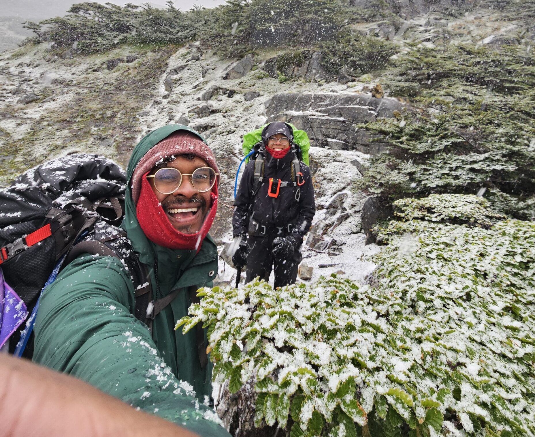
The trail is named for the mountainous prominence the circuit winds around, which look a lot like – well – teeth. If you fly into Puerto Williams, you’ll probably be able to see them out your windows. They really are an impressive rocky feature, like stone canines protruding from mountain gums. The best views (and photo opportunities) are on day one, as you initially climb up into the range but there is plenty to see on the track that will make your own jaw drop!
Click here to take you to ‘Short and Sweet’ that summarises this blog post!
Tell me everything:
Getting There:
Being the end of the world Puerto Williams is not the cheapest or easiest place to arrive in. There’s three ways in and out:
Ferry from Punta Arenas: a 30 hour trip through Patagonia fjords. Apparently, one of the most gorgeous trips you can take, even if the sleeping conditions are questionable.
Fly from Punta Arenas: the quicker option and for a similar price, but you miss out on the experience of the ferry. We did this, and wished we’d taken the ferry!
Ferry from Ushuaia: this is the only way to get to Ushuaia from Puerto Williams, but it is so expensive – 320USD for the ride!
Generally, whichever method you take, your accomodation should offer to pick you up. Puerto Williams is tiny and tourism not a core industry, so the airbnb and hostels are pretty kind.
Accommodation
We stayed with Luis, at his airbnb cabin – it would be at least 40 minutes walking from the town, but it is only ten minutes from the beginning of the Dientes track. We don’t usually comment on where to stay, but we would highly recommend this accomodation – it’s super cute, quiet and an amazing way to disconnect. The family is incredibly lovely, and a friendly homestay lives out the back, too. If we ever found ourselves down that way again we’d stay there in a heartbeat.
The Hike
The Dientes actually has reasonable information on Wikiloc, and the trail is reasonably well marked for the most part. A GPS is still necessary – some sections are confusing and, this part of the world gets a lot of rain so there’s also a lot of bog. Also, clearly, it’s very close to Antarctica – so while not all the track is what would usually be considered ‘alpine’, the weather is incredibly changeable. The passes can snow up and be impassable all year around. If you have the flexibility, arrange to be in Puerto Williams for additional days, and certainly take an extra days’ food and extra dry food, in case you get stuck in your tent. In saying that, the weather forecast should be reasonably accurate – just be prepared that you may arrive and not be able to start in the first place!
The Dientes de Navarino track itself is not very long. The days are around 10km on average. The beauty of the track is in the scenery and the wildness, and being one of the southernmost people in the world. The challenge is in the isolation. You could do it in three days sure – but why would you? You’ll probably never be so far south again, so enjoy the seclusion!
Day 1: Puerto Williams – Laguna Del Salto; 11km, 6-7 hours
The track starts as a day hike, climbing up with switchbacks through forest to Cerro Bandera. There are multiple viewpoints along the way, but the view at the summit is the most spectacular. Treat yourself to the view of Tierra del Fuego. The track then continues along the side of the ridge and towards the Dientes de Navarino. Coming around the ridge you’ll get awesome shots of the Dientes and lakes and rivers below. This is actually the view that our logo is taken from! Eventually, you’ll descend to a lake below the Dientes, where the first campsite is located. All along this route, the campsites are clear with people having set up stick or stone walls to give the tents some shelter.
There is an alternative route into this location, alongside the river, if the winds are too high to walk to Cerro Bandera. We believe some people also walk this as an overnighter loop. There was certainly a large group on the day we stayed at this campsite, and we didn’t see them again.
Day 2: Laguna Del Salto- Laguna Escondida; 9km, 5-6 hours
Where day 1 was all great views and chill walking, day 2 was a shitty slog for us. It started raining at about 8am and didn’t let up until the next day. Day 2 is where you should get even better views of the Dientes, as you pass underneath them and through the mountain pass. We didn’t see anything – to be honest, we can hardly recount the track, except that there was a lot of up to start, and a bit of slippery boulder clambering next to a lake. The campsite on the map is pretty nice, situation by a laguna with a great view (we saw in the morning), but we continued onto the other side of the laguna to get a little more privacy – we knew there were quite a few other hikers behind us!
This was a day we were so glad for our tent setup – we can put the footprint and fly up, then sit in the shelter and dry off before putting the inner up. Awal almost got too cold, but our setup meant that everything important stayed dry. The rain did not stop, so it was a cold bread & cheese dinner for us.
Day 3: Laguna Escondida- Laguna Martillo; 7km, 5-6 hours
We woke up to a smattering of sun and rain, and quite a bit more cold. Today was the day we were the most south we’ll ever be! It was to be a tough day – another pass for the southernmost point, plus snow and wind on and off all day kept us guessing what we should wear. At times, it was a winter wonderland, but it never lasted too long. As we circled the mountains we got spectacular views of the surrounding valleys. On this day you also pass the turnoff for the Windholm circuit which does actually pass further south than the Dientes. The Windholm passes into more difficult territory(verify). After the southern pass, the track circles the mountain for some time before dipping into another laguna for the campsite. We followed the track a little further to find a lovely campsite overlooking that laguna, however we did camp next to a beaver site, so we had to be more careful with our water. We managed to set up the tent before another bout of snow arrived!
Day 4: Laguna Martillo- Laguna Los Guanacos; 10km, 6-7 hours
This was a boggy day. The track carried on down into a valley filled with forest and a lot of waterways, which made going fairly slow. Then, the final pass – where we lost the track multiple times because the way up through the trees was also a bog! We struggled uphill for an hour or so before it changed to a rockier and drier track. Eventually the track levels out to some flat top walking. Some of the cairns are hard to spot, so keep your eyes peeled. Eventually, this last high pass does end – you’ll come to overlook the final laguna and again you’ll have an amazing view of the Beagle Channel. The descent to the laguna is pretty fun (although, if it were icy or snowy it would be awful). The scree is thick enough to run or bound down the slope. The track then travels around the left, to a viewing platform and the campsite. Continue down through the bush for some more sheltered campsites – the wind coming up from the channel can be strong.
Day 5: Laguna Los Guanacos- Puerto Williams; 3km, 3 hours
The last day is meant to be short, but don’t rely on it! The start of this day is filled with beaver dams, tracks and general skulduggery. This makes it really difficult to follow the trail, both because of the misleading tracks and the dams which block the real track. Not so fun fact – all the beavers are introduced, initially for hunting game. However, the beavers have no natural predators, and the trees have no natural defenses, so the result is some serious deforestation where there shouldn’t be any. The result is also a nightmare of a couple of hours, where there is no real track to follow. Eventually, it dries out as the track ascends a ridge and follows it for some time, before descending into a normal forest – we found that the markers were inconclusive in this forest, so keep an eye out and on your GPS again!
The track eventually meets the road by some means. You can follow the road back to Puerto Williams, but we were lucky enough to pick up a hitch and shave a few kms of road walking off our hike. Then Luis’s wife drove us back to the airbnb, we lit a fire and had a warm, toasty evening of celebrating our achievement!
Keep it Short & Sweet:
Trail type: One way
Distance: 40km
Time: 4-5 days
Day 1: Puerto Williams – Laguna Del Salto
Day 2: Laguna Del Salto- Laguna Escondida
Day 3: Laguna Escondida- Laguna Martillo
Day 4: Laguna Martillo- Laguna Los Guanacos
Day 5: Laguna Los Guanacos- Puerto Williams
Important checks:
GPS
Amount of snow/ weather forecast over the next 5 days.
Entry fee: FREE
Camping fee: FREE
Facilities: None (complete camping kit, cooking kit and pooping kit are essential)
It is time for a good ol’ Walkie. That’s what we thought, anyway, with little consideration of two facts: 1, that neither of us had really broken in our new hiking boots, and 2, nor had we had completed a hike since Easter 2024. That’s 8 months to have forgotten what the weight of a backpack does to your perceived fitness (which was at an all time low, post Christmas feasting). Yet there we were, hyped as hell to get on a trail and explore the Chilean wilderness.
This was in the last post, but I feel like it’s important to reiterate – CONAF are great, but not super reliable. A lot of hiking information is difficult to find – in Chile and, as we have found out, throughout all of South America. When we emailed CONAF about the state of the Villarrica Traverse, they didn’t reply for 4 days (we were halfway through the hike!) and they sent me a link to a non-official description of the track, on WikiExplora (http://www.wikiexplora.com/ENG:Villarrica_Traverse). Thankfully, there was a kind local tour guide who answered a number of our questions on Whatsapp. We also got a little bit of information from the tourist office. There were a few key points to note:
The track only opened on the 4th of January, and we started hiking on the 7th Jan. The track was pretty clear overall, but there was reasonable treefall in all the forested sections, which sometimes made our pace very slow.
Most of the waterways rely on snowmelt, so the water situation can be variable, and later in summer it can be tough to get enough water (specifically on the first day)
Make sure you have a filter too – because it’s an active volcano, the waterways can have icky particulates in them.
In general, WikiExplora is your best resource for information on hiking in Chile, and some other parts of South America. AllTrails tends to be less current. Our other go-to has been WikiLoc, which is often updated with photos by locals and local guides.
Part of the inspiration for this blog came through on this very hike – there was so little information! Coming from Aotearoa, where every trail, campsite and hut is detailed, marked, rated, mapped, and maintained by the Department of Conservation – hoo-ee, this was a shock to our privileged hiking expectations. We knew it should take 5 days, and that there were volcanoes to look at. We hardly knew anything else!
Click here to take you to short and sweet that summarizes this blog post.
Tell me everything:
Getting There:
This trek started with us being so damn lucky. We woke up with our bags already packed, had a quick breakfast and were ready to go at 7am or so. Our plan was to call an Uber – we had talked to a few of the tour companies running expeditions up Volcano Villarrica, who had offered us seats in their vans (leaving at 6am!), for 10k per person. When we checked Uber the day before, we saw we could get one for just 10K CLP – and we were feeling budget-y, so we decided, confidently, that an Uber at 7am was a good idea. Open up the app and – what do we have? – no Ubers in Pucon – at all! Several minutes of panicked waiting ensued, until we got a driver – who accepted the ride from Villarrica no less. An insane spot of good luck. The lad had to drive 30 minutes along the lake just to pick us up, before taking us 25 minutes up a dusty, gravel road for his first drive of the day. Plus, he had to wait for us for 5 minutes while we paid out park entrance fees (10400CLP each) and signed in for the trail (there was someone standing at the Guarderia waving cars over, it’s hard to miss). It was a wee car (imagine a tiny Suzuki Swift), too, so we felt every bump along the way. We were so grateful (and felt a little guilty), so we also tipped the guy in cash. Eventful as it was, we had arrived at the ski lodge, and were ready to hike!
Day 1: Volcano Villarrica Ski Lodge to Estero Ñilfe. (4-7 hours)
At this time of year, the ski lodge is used by mountain bikers, testing out the downhill trails. Another previously unknown, not very fun fact – the actual trail for the Villarrica Traverse starts another 3km uphill along a very boring dirt road. The road is reserved for ski-lodge staff. There’s an option to take the ski-lift, but this was a budget-friendly day – we were not paying for none of that!
So we began to trudge, packs weighted and boots poorly fitted. And then – another stroke of good luck. Old mate from the ski lodge (who we’d asked for directions) pulled up in his ute and urged us into the car. He struck up a friendly conversation in English, obviously taking pity on the two gringos who had no idea how long this road would actually take to trek along (at least an hour). Even in the ute, it took us another 5 minutes (uphill!) to reach the start of the trek – which starts in a South Westerly direction. We left him with a flurry of thank-yous, before starting our Traverse in earnest.
Lift from good ol mate
We should preface the remainder of this walk: we had spectacular weather. It was always sunny, with enough wind to keep us cool, but not so much to be a pain in the arse. Another important note for this hike – most of the signs have conflicting distances. A reliable GPS should give you the confidence you need. We were lacking on this front. We bought a second-hand GPS in Aotearoa before we left, but never really tested it out on the trail. Within an hour of starting the trail, it stopped working. An absolute classic! But we were already on the trail, and we were committed to making this hike work out.
The first real section of the track rolls around the foothills of Volcano Villarrica. There are plenty of amazing rock formations to admire, and sections where you can see the differences in lava flows. The scenery differs between harsh rock and wildflowers, always with views down the mountain into the surrounding lakes. Eventually, after moving through some short lengua forest, we arrived at a section which drops from a lightly forested cliff into a flat sandy ravine. The track took us up and across the valley slightly, onto some more volcanic rocks, where there was a lively stream – this looked like a good place to refill. The track then rose up the other side into more forest. Within 30 minutes or so, we arrived at the Challupan Lagunas, which was marked as the first campsite on the map we were given. The lagunas are all quite stagnant and icky, so the water would definitely need filtering. Although the shelter of the trees was nice, we decided to keep going to find a better campsite.
The next ‘water’ on our map was another stagnant non-event, much to our disappointment, but the Estero Ñilfe was running rapid in the next valley along, so we stopped for the night, pretty exhausted and ready to have a rinse and relax. This was probably about an hour along from the Lagunas, and is a wonderful peaceful place, with a great view and the perfect angles to watch the sunset! If you want to go further, there are opportunities to camp further along, but stock up on reasonable quality water at Ñilfe.
Day 2: Estero Ñilfe to near the CONAF Guarderia (6-8 hours)
This day starts again with more volcanic walking – called the “Valle del Fuego”, the valley of fire. It sounds like more of the same, but the changing angles of Volcano Villarrica to your left and the valleys and lakes far to your right really are spectacular, and will keep you entertained for hours. The track eventually started winding through steeper hills with sheer drops, past summer flowers of reds and orange filled with buzzing bees. At the top of this section, you can turn off for a few minutes to the Mirador Los Volcanes, but the main track turns to the right and begins a steep downhill to the Rio Pichillancahue. This Mirador is accessible from the road, so we met a few families puffing their way up the hill on an afternoon dayhike.
Our experience of this next section was, to be frank, not fun. Descending into the Rio Pichillancahue almost made Emma cry. The track is very steep (at this point we didn’t have poles yet – rookies), and we were still carrying extra water ‘just in case’. Being heavy going downhill equates to some very sore knees.
Secondly, the bottom of this descent was marked clearly on two maps as the next campsite. But there are massive signs that clearly say “no camping”. Like, what??? So Rio Pichillancahue is a good place to restock water before continuing on.
Finally, this next section of track is pretty weird walking. Coming out of the ‘no camping’ area by the river, turn left to continue along a rutted out 4×4 track. This track winds up the hill, towards a turnoff for the Pichillancahue Glacier (we met some guys earlier who had all the gear to walk on the glacier – pretty cool stuff). Continue following the road up to the highpoint, and then back down the other side of the hill. Partway down, there’s a sign that says “Chinay Campsite”, essentially on the roadside, with average access to the water and no real grass to pitch your tent, just some dirt that has slightly less gravel. Also weird. We continued on.
Eventually, the track meets up with the river properly, and the water is easy to dip into. Another few hundred meters along is the CONAF Guarderia. We stopped as soon as we found the river, setting up our tent in what was essentially a parking lot (remember, some of us were very close to tears a couple of hours earlier). If you continue past Guarderia, you’ll cross the track over a small bridge, and there is a much nicer spot to camp in a grassy area with great water access. We saw another tent there the next morning.
Day 3: CONAF Guarderia to Laguna Azul (6-8 hours)
Day 3 is the toughest day, with the most elevation gain. We first checked in at the Guarderia. He checked our passes, gave us some guidance on the track, and sent us on our way. “On our way” really meant “sent us up the hill”. The day begins with 3 hours of ascent, mostly switchbacks, rising through a forest of Aracuanias. We took our time enjoying the views and taking breathers. Eventually you rise above the treeline and rise to a high point, where you can enjoy 360 degree views of your surrounds, including views of all of the volcanoes! There were a few wind-walls set up when we were here, so this does seem like a place you could camp if the wind is calm enough. We enjoyed the views here for a while, but the horseflies here were real arseholes, so we didn’t stay too long.
360 views at a highpoint
The descent from the viewpoint takes you through some scraggly, low-hanging lengua forest. There are equal opportunities to smack your head (Awal) and trip over roots (Emma), so take care. Eventually, you descend into some thicker forest, which is quite beautiful but unfortunately the high quantity of snowfall in the area means there is a lot of treefall. The track is not super well maintained, so expect this section to be slow-going, with a lot of rerouting and clambering over branches to keep you entertained. After a dip, where another track meets up from the road end, you’ll start climbing again. Tricked! The first three hours up didn’t actually take you to the highpoint on the track, but now you will climb up to it. Another 30-60 minutes will take you through to the edge of the forest, and then you will see the track disappearing off into the distance, on a saddle next to volcano Quetrillipan.
When we completed this section, there was plenty of snow melt. The scenery is rugged and stunning. The mounds of snow are melting into rivers into water, and plenty of them make waterfalls that fill the valley. The section is mostly rock and scree, so expect some scrambling amongst the snow walking. During the last 400m of ascent, take regular breaks to look back across the valley. Once you near the top, check your GPS again to ensure you’re heading in the correct direction, slightly to the left. The track then curves down and to the right, eventually giving you a gorgeous view of your campsite. If you’ve got snow in the right places, this is an excellent opportunity to enjoy some sledding on your ass – it’s way more efficient and wayyyyyy more fun!
From the top, it should only be about 30 minutes or so descending into Laguna Azul. Enjoy the views of the laguna and the valleys stretching out from the foot of the mountain as you walk. Once at the base, pick your camping spot amongst the small grouping of trees or pick one right on the beachfront. Take a well deserved swim and relax in the best camping spot on the track!
Note that this campsite can be accessed from the road, so it may be busy on weekends, and unfortunately there was quite a bit of rubbish there when we visited 🙁
You can actually summit the Quetrupillán volcano if you so wish, either for a magically sunrise or just for bragging rights. Instead of going all the way to Laguna Azul, pick a camping spot of your pleasure to prepare for your ascent the next morning. The peak sits at 2370m.
Day 4 – Laguna Azul to Laguna Avutardas (5-6 hours)
This day will let you traverse some very cool trail through scree and sand valleys. There is really no shelter for most of this day, so ensure you have lots of water.
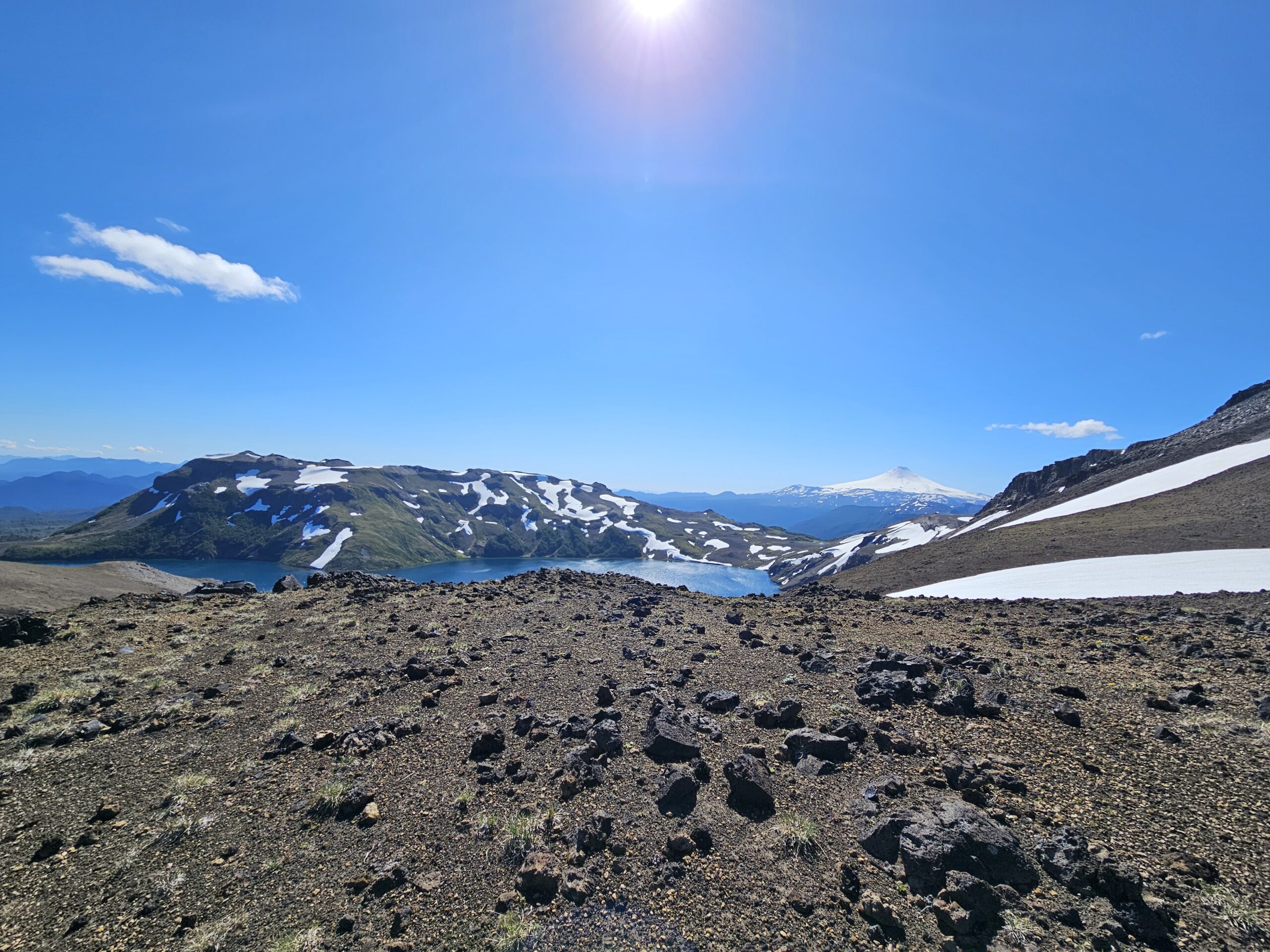
The track initially almost doubles back on itself – you may have been able to see it coming into Laguna Azul the day before. Pick your way through the volcanic rock field until you reach the well marked trail – and don’t rip any of your clothes in the process! Your first viewpoint will be Laguna Blanca, a milky white lagoon made so by the chemicals in the water. There’s a track that goes to the lakeside, but there’s a small rise you can run up, just as you come over the hill and first view the laguna. We’d recommend doing that, it’s a pretty good viewpoint!
Whichever method you decide to take, the track winds for some hours into real mountain valleys. It’s very dry and barren here. At some point, the track technically crosses the border from Chile to Argentina and back again, although it’s not marked! The track in general is a bit sparsely marked here, and with large sections of snow it can be difficult to see any marked path. Keep an eye on your GPS.
Eventually, the scree and the sand will stop, and you’ll have a view of your next couple of hours of descent – first into a valley of scrubby alpine grasses and lengua, and further afield into a humid forest. This is a great place to take lunch, and appreciate the sound of snowmelt and views of the trees and rugged rock formations that make up this next valley.
Because of the snowmelt, the initial section can be quite boggy. Take care where you put your feet, and generally prepare to get a little wet. As the track crosses this wetland and begins to descend into forest, the same applies – the track basically follows a big slip down into the valley, and the soil is full of clay. The red colour is a lovely contrast in photos, but for walking makes a big slippery mess. As you descend, you’ll be able to see your next camping destination – Laguna Avutardas. Check your GPS regularly as you descend – there was one grassy clearing where we missed the track direction, and ended up confused for 15 minutes or so.
The Laguna Avutardas Camping area is a little back from the beach, although it’s possible to camp on the beach if you want to be close to the water. The lake is shallow, but certainly swimmable – a lovely end to another day on the trail.
Day 5: Laguna Avutardas to the highway at Mirador Parque Villarrica (3-5 hours)
The final day is short on paper, but as with all the forested trails you’ve been on in this hike, will be filled with treefall. There’s a lot of rerouting and clambering on this day, so the track time can be very variable. We found sections quite boggy too, so we had some careful stepping. It’s not hard – there’s not too much descent – but it is slow going for the first couple of hours.
The track will eventually transform from trail to a dusty 4WD track, which you will follow for another 30-60 minutes before arriving at a suspicious, unmarked gate. Open it and finish the track! We didn’t, and assumed that it was part of the ‘do not pass fence’. Instead, we turned right and hiked uphill (a very, very steep hill) for about 15 minutes before the trail disappeared. The trail was, in fact, made by cows. It was several minutes more of map checking, scrambling and swearing before we eventually descended again, opened that damn gate and completed the Villarrica Traverse. Now all we had to do was figure out how to get back to Pucon.
Getting Out
This trek also ended with us being very lucky. Having taken our little detour, we were pretty over it! There’s a carpark where the track finishes, and a little cafe. It was a Sunday, so there were several people arriving to begin their day hikes – but not many people going in the other direction, as the road only comes in from Argentina. We sought advice from the staff at the Villarrica Traverse Cafe, who were super helpful and kind, offering us water and WiFi. Unfortunately, the advice was that 1) the bus from Puesco Bajo doesn’t run on a Sunday 2) the track running next to the road was closed, so we were definitely going to have to trek to Puesco Bajo via the road. Thankfully, the track finishes at a high point, so the trek to Puesco Bajo is all downhill. If you want to chill or can’t get a hitch, there are hostels in Puesco Bajo, or there’s a CONAF campsite (according to our map – which was wrong in all other regards, so take this with a grain of salt).
We were lucky enough to grab a hitch with a couple of Argentinians within about 20 minutes. They’d come across the border for their Sunday shopping (which really shows you how crazy the economy is in Argentina!). There were actually a couple of girls who were already in their car, hitching, and they kindly jumped out for us. We rode with them all the way back to Pucon, which is about an hour’s drive. We’re sure they were very friendly people, but our Spanish was still terrible at this point, and the Argentinian accent really is something different! So it was a bit of a quiet ride.
The GPS Drama
So, we’ve got an ETrex25 Garmin. It must be about 15 years old. On the track, it suddenly wouldn’t turn on anymore. Stressssss. Since then, we guess because we were stress-pressing it so much, the power button has collapsed in – the silicone is too old, and it cracked and crinkled until it couldn’t take anymore. This means that this lovely, rugged model is no longer waterproof. Whoops. Also the only way to turn it on is with a Q-Tip. Difficult with gloves! Anyway, it turns out that the issue was the SD card. If the SD card isn’t sitting absolutely correctly in its slot (and it doesn’t love to sit straight), the misconnection causes the Garmin to freeze. Because it doesn’t sit very well, it’s really easy to mess up the connection when changing the batteries!
We’re not sure if there’s anyone who’s had the same issues, but this is a good lesson to always have a backup GPS – or maybe to test your gear properly first…
Keep it Short & Sweet:
Trail type: One way
Distance: 73km
Elevation:
Time: 4-6 days
Day 1: Volcano Villarrica Ski Lodge to Estero Ñilfe.
Day 2: Estero Ñilfe to near the CONAF Guarderia
Day 3: CONAF Guarderia to Laguna Azul (the best campsite on the trail!)
Day 4: Laguna Azul to Laguna Avutardas (attempt Volcan Quetrupillán summit on this day)
Day 5: Laguna Avutardas to the highway at Mirador Parque Villarrica
Important checks:
State of the waterways
GPS
Amount of snow/is the track open
Entry fee: 10800CLP
Camping fee: free
Facilities: None (complete camping kit, cooking kit and pooping kit are essential)
Getting there: 10000CLP pp with a tour company ascending Volcano Villarrica (6am start); call an uber from town (~10000CLP); hitch hike (free)
Getting back to Pucon: Hitch hike (free) or catch the bus from Puesco Bajo (it does not run on Sundays, and is ~7km from the end of the trail)
There are some things that are on every tourist’s bucket list, and this hike is one of them. If you are heading to Patagonia, then this trek really is a ‘must-do’.! This 8 day trail will take you on a 120km adventure around Torres Del Paine (TDP) National Park. You will see beautiful glaciers, beautiful lakes and the famous Torres.
This post will equip you with all you need to know if you are planning to complete the O-Circuit. The O-circuit is usually open from November to March, although the track can see snowfall and heavy winds all year around.
We completed this trek with all our own gear. We had our own tent, food, sleeping bags, mats, liners – the whole honky. It’s nice to be able to rely on your own gear, and cheaper to boot. We assume you want to do the same thing, so all costs will show how to book this as cheaply as possible.
If you are only here for planning purposes and only want key info about the trek, then please CLICK HERE to take yourself to ‘Keep it Short and Sweet’. This section at the bottom of the post will provide all the essential info for planning & logistics with no extra details. We get it! Sometimes you just want to enjoy it by experiencing it on the trail.
Tell me everything:
Why the O-Circuit?
Whilst researching what hikes to do in Patagonia, the O-Circuit will definitely come up on your radar. Most likely, it will be on every single “South America Hiking” list you look at, and even on some ‘top 10 hikes in the World’ lists. There are 2 main treks you can do in Torres Del Paine National Park, the O- Circuit and the W-Trek. Old maps show that there used to be several extra tracks around the park, but most have been closed, for a combination of conservation and tourism management.
The O-Circuit is a loop around TDP national park. You can only do this loop in an anti-clockwise direction, in the Patagonian summer and shoulder seasons (Dec – Mar is easiest, Oct/Nov and April you may get snow). The loop makes its way around the north side of the park and meets up to include the W section at the ‘front’, southern side. It totals up to 120km over the 8 days. The alternative W-Trek can be completed in 4 days, in either direction, but it is only a one way track. You have to ferry in or out, although we did hear that some people were planning to walk from Paine Grande all the way back to Central.
For the rest of the post we will only be talking about the O-Circuit. The W-Trek is far more popular, and far more trafficked – fair warning for those attempting the O-Circuit and arriving into Refugio Grey! The W-Trek is shorter, more easily accessible, and has more of ‘classic’ photogenic spots, but we wanted to do the O-Circuit for a few main reasons:
We love spending time on the trail!
We prefer taking the path less traveled
Glacier Grey – a sight which has become one of the highlights of our trip
How do I plan this hike?
When we were in the planning stage, we were overwhelmed with information. There is a lot to process before booking this trek. We will take you through everything you need to know from organising buses to organising shuttles to buying the park entrance tickets and most importantly, booking the campsites!
Firstly, let’s start with figuring out what the 8 day itinerary looks like with the relevant campsites/refugios. All of the refugio/campgrounds have flushing toilets (!) with toilet paper, and most have hot showers. There are no cooking facilities for campers, so you need your own cooking system. There is boiling water available in some refugios, but it wasn’t super consistent. All of the sites have a minimart with a variety of small (expensive) snacks and hiking gas if you run out. On the W-side, there tends to be spare gas left behind by those who don’t need it, so if you get in early you can avoid paying for extra.
Day 1 | Start at Central and hike to Serron to stay the night | Managed by Las Torres
Day 2 | Hike from Serron to Dickson | Managed by Vertice
Day 3 | Hike from Dickson to Los Perros | Managed by Vertice
Day 4 | Hike from Los Perros to Grey | Managed by Vertice
Day 5 | Hike from Grey to Paine Grande | Managed by Vertice
Day 6 | Hike from Paine Grande to Frances or Cuernos | Managed by Las Torres
*Day 7 | Hike from Frances or Cuernos to Chileno or Central | Managed by Las Torres
**Day 8 | Hike from Chileno or Central to Las Base Torres Lookout, back to Central and out of the national park.
*Frances or Cuernos are fairly interchangeable.
**Chileno is much better, as you cut 2 hours off your sunrise wakeup time! But it fills up super fast, so you may need to stay at Central.
There are 2 companies you have to book through, called Vertice and Las Torres. In the past, you could stay at the CONAF campsites for free but they are now closed. While we were on the trail, we had some chats with the CONAF park rangers, and they indicated that the cheap campsites will likely never reopen. CONAF now works with Vertice and Las Torres to upkeep the track and park as a whole.
As we’re sure you can imagine, this is quite a chaotic working relationship, which makes your life as a tourist confusing as hell. Vertice and Las Torres release the dates for booking at different times, with very different pricing models The release time varies year on year but should be sometime between April and June. The prices increase annually so the only way to know how much each campsite will cost will be when the company opens up the bookings. For our 2025 bookings of the Vertice campsites, we paid $11USD per person and for the Las Torres campsites we paid $40USD per person. Yes! This is to camp, bringing all of our own gear… so it is ridiculously expensive. All you get is a piece of ground that you can pitch your tent up in and access to a hot shower. At those prices, you’re damn right we used the showers!
If you have a fixed time frame you can go to Patagonia, then booking well in advance, as soon as the spots are released, is your best bet. We would recommend joining the reddit Patagonia page as when the bookings are open, info generally gets posted there first. At the time of writing, Vertice 2026 bookings are already open – so get booking!
We booked the ‘simple campsite’ option as this one does not include any extras and is the cheapest. This also books out the fastest. Though, don’t necessarily trust what the company tells you. We had a pretty crazy time booking the simple campsite last year. The bookings at Las Torres opened online with no option for a simple campsite. Awal then proceeded to spend a couple of days going back and forward (via WhatsApp) with someone at Las Torres, who insisted that there was no such thing as a simple campsite, despite all the evidence to the contrary! We eventually managed to book the spots, but there was a pretty stressful time where our Vertice spots were booked and our Las Torres ones were not. And once the simple campsites sell out, the premium options are crazy expensive – and they really aren’t very ‘premium’
If you’re getting a bit overwhelmed and have some cash to spare, there are 3rd party companies that you can book with, which will save you from booking with Las Torres and Vertice directly. There’s about a 15% markup for the service. The most popular one is Torres Hike: https://torreshike.com/en
If you’ve already missed out on your ideal dates, don’t stress too much. The simple campsites can become available at a later date. This is because Vertice and Las Torres reserve some campsites for tour agencies to use up. If they are unable to sell it, the campsites become available. We came across a family of 5 who booked a week before! This comes with its risks – but we know there are people out there who froth that kind of last-minute organisation.
Once you have booked your spots at each location, you need to book the bus that will take you from the town of Puerto Natales to Laguna Amarga. Laguna Amarga is the entrance of the National Park. You can find buses through BusBud [https://www.busbud.com/en]. You don’t need to reserve this bus months in advance (in fact, you can’t), but it’s worth checking a week or two before to make sure you can get on one of the earliest buses. There will be many people who catch the bus for a day hike to Las Torres, not just people completing the O- & W-Treks. Try to book the earliest bus which will leave around 6:45am from the bus terminal in Puerto Natales and will arrive at Laguna Amarga at 9am.
TIP: throughout your travels in South America, you can find buses through BusBud and then jump on the website of the bus company to buy your ticket there. It will save you just a few $$, but over time it all adds up.
The day you catch the bus from Puerto Natales to Laguna Amarga, you will then need to present your national park ticket at the registration area. The ticket can be bought up to a day before you start the hike. The ticket to the national park can be bought here: https://www.pasesparques.cl/en/parks/torres-del-paine. We have heard some tales of people skipping the park entrance fee – there’s not a very efficient system at Laguna Amarga, so we could see how this would be doable. However, CONAF does an awesome job of servicing this park, the money really does go straight to them, and the systems in place are really effective for managing tourism, so we would definitely encourage you to pay your fair share 🙂
Once you have checked in at Laguna Amarga with your park entrance ticket, you will walk about 400 meters to the shuttles that will take you to Central which is where the hike begins – you cannot book these in advance but yes, there will be enough shuttles for everyone – don’t stress. The shuttle cost us 4500 CLP each.
TDP Park Rules and Guidelines for etiquette:
You can only camp at the designated campsites
No open fires allowed. You’ll read a story about a dumb traveller who tried to burn some toilet paper and set fire to a large portion of the park.
You can only use a burner at the cooking areas at the campsites.
You can drink the stream water and water is drinkable at all the campsites
Check In to campsites are usually from 2pm. If you arrive early with a reservation to the campsite, the staff will let you set up your tent whilst you wait to check in.
The checkout times are only for those staying at the refugio and staying in a pre-made tent as they need to be cleaned for the round of hikers. This being said, spending more time on the trail and appreciating the views outweighs sleeping in.
You need to have your campsites booked before you arrive
You are not allowed to hike at night. We weren’t specifically told this but there were lots of signs pointing to this act.
Please note that swimming is not allowed in the national park. It might be tempting but, these are the rules for the park. We noticed many travellers breaking the rules and this is not a good look!
Now the fun part, TREKKING!
Below we will provide a description of what to expect on the O-Circuit, based on our own experience. One thing we can’t predict is the weather; this will vary dramatically in Patagonia, even over the course of a single day. Do note that your timings will be equally variable depending on the weather and your level of fitness. For reference: we’re fairly fit, but we also like a good sit-down in the middle of the day. If you are concerned about not being able to do it, trust us, you can! The track is in great condition, and there are plenty of people around to offer encouragement. If you know you are a slower trekker, start earlier in the day, take plenty of breaks, and trust your own pace. Another important note: every blog, website, signpost, you name it, will have a different distance and time on it.
Day 1: Central to Serrón (Approx. 13 km, 4-6 hours)
Your trek will begin at Central. There is a tourist shop you will walk through before beginning the hike. We recommend not buying things until the end of the trek as you will just have to carry it. The trail winds through recovering farmland and you will mainly be walking on a 4×4 track that Las Torres use to service their refugios and campsites. It’s not great walking, but about halfway through you get views of a glacial river, which is a stunning colour. Upon reaching Serrón, you will set up camp, have an afternoon tea, socialise with the other campers and those in the refugios, take a nice refreshing shower and enjoy a peaceful night in the park.
Day 2: Serrón to Dickson (Approx. 18 km, 5-7)
On day 2, hike from Serrón to Dickson. The trail is filled with scenic views and takes you through more diverse terrain than the previous day. You will pass Guardaria Cuoiron where you will need to sign in by showing the park ranger your booking for the campsite ahead. A screenshot is all that’s required. As you approach Dickson, you’ll be greeted by breathtaking views of the mountains, lakes and the very top of a Glacier, if you’re lucky. Settle in for the night at Dickson. We would recommend taking your time on this day as it is mostly flat and you will begin to see the beauty of Patagonia, as the day before was merely on a 4×4 track. If you wake up in the middle of the night, do some star gazing. The night sky is beautiful!
Day 3: Dickson to Los Perros (Approx. 12 km, 2-4 hours)
On day three, trek from Dickson to Los Perros. This section of the trail is mostly a gentle uphill as you climb the valley, and features lush forests that eventually turn into a rugged glacial valley. You will also begin to cross dodgy bridges at this point, maximum one person per bridge for good reason. There will be a few of these over the next few days and it honestly does not get better until you reach the more travelled W-Section of the hike. Towards the end of the day, you will be greeted with the beautiful Los Perros lake along with its glacier – very cool to see, but it has receded a lot. However, never fear, tomorrow you’ll see the real deal. After a pleasant but short day on the trail, arrive at Los Perros, which is a beautiful campsite nestled nicely into the forest, away from the winds where you can recover, chill and have an early night. The next day will involve a very early morning wakeup!
Day 4: Los Perros to Grey (Approx. 18 km, 6-12 hours)
Our View of Grey Glacier
Today’s hike is probably the toughest. It will take you from Los Perros to Grey, through the John Gardener Pass. This can be a very long day, somewhat dependent on your fitness, but realistically mostly dependent on the weather.. CONAF are very strict about the timing. You must be out of the campsite by 7am but they recommend starting at 5am or 6am. This is because you must arrive at Paso Guarderia below the pass by 2pm or they won’t let you continue, and you have to stay there for the night. From Los Perros, it is a steep, exposed climb uphill to John Gardener Pass; when we completed this section, the winds were pretty mental. Lots of rain covers were lost and people were being blown over so start early and take your time. CONAF will brief you on the weather the day before. Once you cross John Garner pass, you will be greeted by the beautiful and majestic Glacier Grey. If you’re really lucky with a clear day, you should be able to see all the way up the Glacier to the Southern Ice Fields – the 3rd largest continuous sheet of ice in the world. Just take a moment at this stage. One of the most breathtaking views we have ever seen.
After admiring the glacier, you will head into the forest for a steep descent until you get to Paso Guarderia. From Paso Guarderia, it’s another 3-4 hours descending towards Refugio Grey, along which you will find many opportunities to take in stunning views of Glacier Grey until the Refugio, where you will take a well deserved hot shower, have dinner and get some well earned shuteye.
Day 5: Grey to Paine Grande (Approx. 11 km, 2-4 hours)
This is a short day, only around 3 hours, so we had a really nice sleep in after the long day before. The trek to Paine Grande is very gentle as you will be trekking along a mountain edge alongside Lago Grey where you’ll be able to see Glacier Grey from another beautiful angle. Take your time and take it all in. The trek ends next to the beautiful Pehoe Lake where the Paine Grande campsite is located. We tried to resist buying anything from the minimarts but we caved in here and got some snickers! A well deserved treat! This is the most exposed campsite in the park. We were there on a very sheltered day and had nothing to worry about, but if you hear horror stories about tents getting destroyed – this is the place it happens.
Day 6: Paine Grande to Francés (or Cuernos) (including Miradors Frances and Britanico ~22 km, 6-8 hours)
On day six, hike from Paine Grande to either Francés or Cuernos. On this day, you must make two choices. The first is the direction you approach Guarderia Italiano – there’s a fork about 10 minutes after leaving Paine Grande, with the right option taking you in between lakes, ponds, trees and a wetland, and the left option taking you along the base of the mountain. We took the right option (not knowing the difference) and it is much less travelled, if you’re looking for a quieter morning. We only walked past one couple, right at the end. It did feel quite exposed though – we nearly lost two pack covers on this day!
The tracks meet back up at a bridge. The next decision must be made at Guarderia Italiano, where you may leave your bags and take a steep trek up to Mirador Frances (2.6km one way) and Mirador Britanico (5.8km one way). This is the middle line in the “W”. Mirador Frances is approx half way to Mirador Britanico, and the total elevation gain is about 800m. This means that there’s a good chance the weather at the base is not the same as the weather at the Miradors. On the day we did it, we walked up to Mirador Frances but not to Mirador Britanico as we ended up in the clouds, soaking wet, without all our layers. Please consider taking your warm & waterproof clothes even if it is not cold or wet at the bottom. It’s so changeable, and especially without your full pack you might regret it!
Mirador Frances is stunning, even during bad weather. We recommend you don’t miss it. The hike is steep and involves clambering up lots of big boulders. Don’t feel like you have to rush – though we did, enjoying the thrill of walking without a full pack. Britanico is also supposedly gorgeous, although we can’t comment – see photo evidence of the ‘view’ before we turned around, about 30 minutes from the Mirador.
Once you descend back to Guarderia Italiano, you will walk 20 – 30 minutes to your campsite at Frances. The trail passes straight through the camping/refugio area so you shouldn’t miss it! The camping check-in kiosk is located up a little hill. Frances has a beautiful common area inside the minimarket where you can spend the afternoon drinking tea (free hot water!) and journaling or reading. In the evening, this area is used for the trekkers who purchased dinner, so we retreated to our campers’ shelter.
Cuernos is a few kilometers further along the trail, so if this is your campsite expect a slightly longer day (30min – 1 hour).
Day 7: Francés (or Cuernos) to Chileno (or Central) (Approx. 14 km)
On this day, you will pass through Cuernos campsite (or not, if you stayed here) and continue your trek alongside Lago Nordenskjöld. This is a pristine blue lake where you’ll have the opportunity to take some photos and take in all of nature’s beauty. As you continue your trek, you will come across a turnoff that says ‘shortcut to Chileno’. Take this shortcut if you are staying at Chileno, or if you want to see Las Torres on this day, as it means you don’t have to walk all the way to the turn off on the W section. If you are staying at Central and don’t want to ascend Las Torres, take the normal route. It was a very worthwhile shortcut, and probably cut an hour off our time.
To Chileno, the trek becomes a slog uphill, and when we did it, boy was it windy. At some points, we had to stop & brace so we didn’t get blown off the track! After about an hour more, you’ll join the main track to the towers. Soon after is ‘Paso Viento’, the windy pass. And holy f***, it gets windy. This is the most exposed section of the entire track, with the valley creating a wind tunnel especially for your hiking pleasure. It can be scary but it’s so awesome – enjoy it! But we definitely recommend using hiking poles. This is the last section before you find the Chileno campsite which is nestled in the forest and reasonably sheltered. Make sure you get an early night because tomorrow you will wake up at 3am to make your way to Base Torres lookout for one of the most beautiful sunrises you will ever see.
Day 8: Chileno (or Central) to Las Base Torres Lookout, back to Central and out of the National Park (Approx. 10 km)
Sunrise shot at Base Torres
On your final day, it’ll be an early wake-up if you want to see the sunrise. You can leave your main pack in the lodge (both Chileno and Central allow this) and only take a day pack up, which is a great relief! From Chileno, it’s on average 2 hours to Base Torres. Because you won’t have your pack, and it’s cold as hell, you’ll probably be hustling. It took us 1.5hours, which was kind of a mistake… we just had to freeze at the top for even longer (not ideal). Additionally, we asked the staff what time sunrise was and they said 5:30am. The sunrise was actually at 6:30am. Even more freezing time 🙁
PLEASE, take warm clothes with you. Sure, you will already be in some warm clothes as it’s a cold start to the morning but by the time you get to the top, you will stop moving, your body will start cooling down and you will get coldddddd. Yes, this is advice from experience. Awal ‘forgot’ one layer and got super cold at the top so we had to leave a bit earlier than we wanted to. Don’t make the same mistake we did!
The harsh dawn sunlight shining on the towers is a sight to behold. Keep warm and enjoy.
After you’ve soaked up all Base Torres has to offer, hike back down to Chileno, pick up your pack and hike all the way down to Central. From here, you will catch a shuttle back to Laguna Amarga, another 4500CLP each. DON’T STRESS, there will be enough shuttles for everyone. There is a shuttle timetable on the board at central. It aligns with the buses that will transfer you back to Puerto Natales. We caught the 2pm shuttle to Laguna Amarga, as we had booked the 3pm bus. There is an earlier bus, at 11:30am, with a 10:30am shuttle. We arrived at 10:35 – classic. However, the 11:30am bus was full anyway, so if we had taken the shuttle, we would’ve been sitting at Laguna Amarga for hours. Moral of the story? Check the schedule when you arrive, but really just take your time. We were hustling back to Central in the hopes of moving our bus ticket, but what it meant was we spent the least time on the trail and the most time in an incredibly expensive cafe with no food left to eat. Eight days on the track makes two very hungry kiwis.
So, was this trek worth it?
Heck yeah! The trekking, Glacier Grey, the lagoons, the amazing people you will meet along the way. This trek is one of our favorites and we will recommend it to everyone we know.
Yes, it is expensive and some would even describe it as a money grab. We were hesitant when we realised how much it cost but we made sure we got in early and booked the absolute cheapest option.
Keep it Short & Sweet:
Why do the 0-Trek?
Beautiful lagoons, glaciers and mountain views. Well managed tracks.
We say: it’s worth it.
How Long is it?:
120km, 8 days
What do I need?
To do it cheap: take all your own hiking gear ($$$)
To do it fancy: stay in a combination of pre-setup tents and refugios, totally catered ($$$$$)
For everyone: Standard mountainous hiking gear – good base layers, proper hiking shoes, proper waterproof gear. All of the refugio/campgrounds have flushing toilets, showers, and toilet paper. Boiling water is available in most refugios. There are no camper cooking facilities (you will need a stove). If you don’t have enough food, snacks are available at all refugios.
When do I go?
October – April (best luck for weather Jan-Mar)
What do I need to organise?
Book Campsites/Refugios – as soon as they open, generally April-July.
Standard itinerary and Booking Information:
Day 1 | Start at Central and hike to Serron to stay the night | Managed by Las Torres
Day 2 | Hike from Serron to Dickson | Managed by Vertice
Day 3 | Hike from Dickson to Los Perros | Managed by Vertice
Day 4 | Hike from Los Perros to Grey | Managed by Vertice
Day 5 | Hike from Grey to Paine Grande | Managed by Vertice
Day 6 | Hike from Paine Grande to Frances or Cuernos | Managed by Las Torres
Day 7 | Hike from Frances or Cuernos to Chileno or Central | Managed by Las Torres
Frances or Cuernos are fairly interchangeable.
Day 8 | Hike from Chileno or Central to Las Base Torres Lookout, back to Central and out of the national park.
Chileno is much better, it’s closer to the towers & you can more easily wake up to see the sunrise. It’s also much more popular.
As above, there are 2 companies you book campsites/refugios with:


![Essential Guide to the O-Circuit in Torres Del Paine | [2024/2025]](https://worldwide-walkies.com/wp-content/uploads/2025/03/20250126_112657-2-scaled.jpg)

