Tag: el chalten

  • Los Glaciares in El Chalten: Patagonia’s Most Famous Hikes & A Moral Conundrum 

    Los Glaciares in El Chalten: Patagonia’s Most Famous Hikes & A Moral Conundrum 

    It’s curious to consider how a region gets famous, and the fine difference between popular and overrated. Is it the difference between online-generated expectations and reality? Is it the crowds of people? Is it the burgeoning prices? Or some perfect, unfortunate combination of the above.

    Parque Nacional Los Glaciares is probably the most heavily visited area of Patagonia, iconic for Petito Moreno Glacier in the south, near El Calafate, and for the Cerro Fitz Roy mastiff in the north, by El Chalten. The accessibility of natural beauty from these two towns is a key reason for their popularity. Petito Moreno is an hour bus ride each way, but only a 30 minute walk to see an advancing glacier. And while trekking to Fitz Roy is a fairly long day (25km return), the trailhead is right in town. These two small Argentine towns have a mountain-village charm that – for us – was somewhat worn down by exorbitant prices. 

    Prior to summer 2024 – 2025, there were no fees to enter Los Glaciares. Prior to January 2025, there were no camping fees in the park, and wild camping was permitted – but all of this changed, quickly, without warning, and without the infrastructure to support the changes. 

    Entry to Los Glaciares now costs 45k ARS per day – although Guardparque Stations only exist on some trailheads, and the Guardparques are only serviced from 7am-5pm, so avoiding the fees is very much doable. A night’s stay at any of the campsites in the park costs 15K ARS per person – with long-drops available, but no campers’ shelter.

    As in our previous budget posts, the high cost of goods is some unlucky combination of Argentina’s changing economy and Patagonia’s isolation, but all prices are also driven by demand, of which there is plenty. Of course, we are complaining as reasonably well-off tourists – so if we found the prices in supermarkets rough, it only stands that the locals have it even harder.

    But while consuming food and booking accommodation supports the local community, it sounds like the changes to the park and park fees themselves are having little impact on the local people or the park maintenance itself. Although, whether that is the truth or a tale designed to make us all feel better, we have no proof.

    We’d say that in general, we’re pretty rules-driven people. We like lines. We think sign-in books are cool. We’re comfortable paying for an honesty campsite. And we both instantly feel guilty when we do something that we know isn’t right – so camping in Los Glaciares was a mixed bag for us. 

    We planned the trip to El Chalten based on information collected from the previous year – which turned out to be wildly wrong. It wasn’t until we had booked flights in and out that we checked again – on reddit – only to find out about all the changes to prices. We were already massively over-budget in Patagonia (a good start to a year travelling!), and couldn’t even remotely afford an extra 60USD each per day. Our only option was to hide out in the park, free camp in secluded places, and enjoy the solitude as much as possible.

    Tell me everything:

    Overall, we spent 11 days in Los Glaciares, with one restock. Five days were on the Huemul, which we’ve detailed in another post, then another 6 in the ‘main’ section of the park.

    Skipping Petito Moreno

    We flew from Ushuaia to El Calafate, as we’d already travelled through Punta Arenas and Puerto Natales, and didn’t need to return (and it ended up cheaper). We decided to only spend a single night in El Calafate, skipping a visit to the Petito Moreno Glacier. If you’ve the cash to burn – don’t do what we did! It does sound spectacular. The walkways are close to the glacier front, so you get stunning views all around. In the afternoon, it’s supposedly common to see the glacier calving, where it sheds chunks of ice. But it’s 45k ARS entry (as part of Los Glaciares), plus 50k ARS for the return bus. That’s about 100USD ea…

    Bus Prices: Calafate to Chalten

    Talking about extortionate – buses in Argentina are far more expensive than those in Chile. The three hour ride between the two mountain towns will set you back 38K ARS per person, each way. Apparently, there is one bus that’s cheaper, but we don’t think it runs often (or at all) anymore.

    Camping at Laguna Sucia

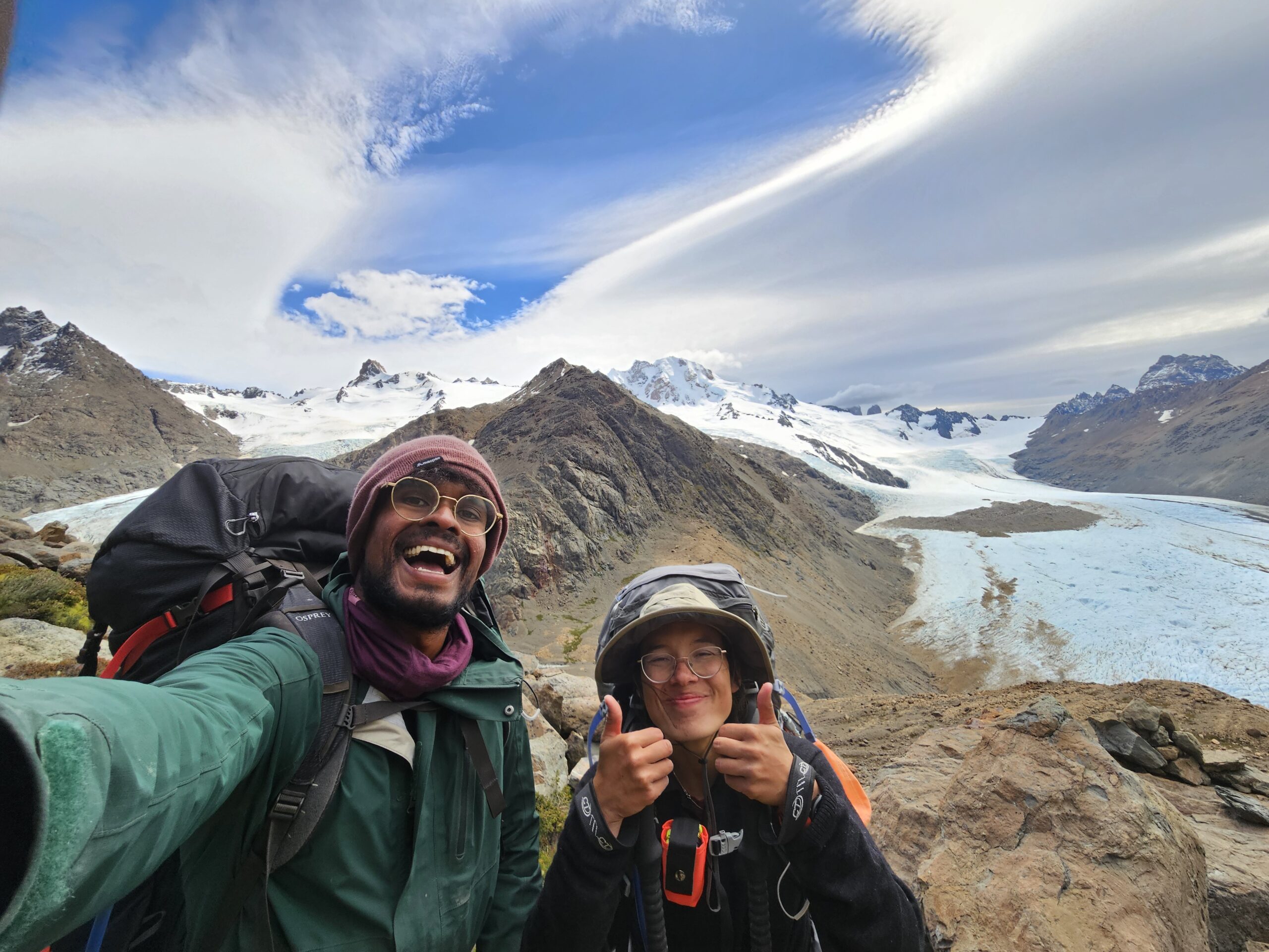
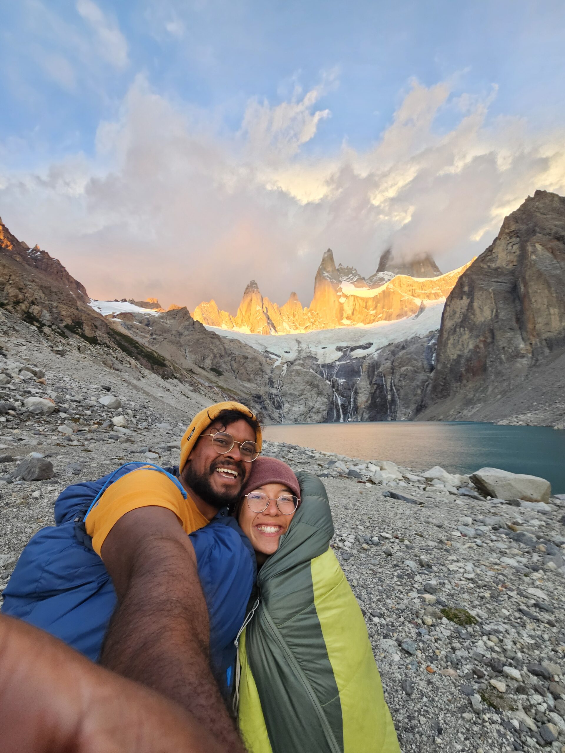
    After the Huemul Circuit, we restocked and reentered the park late, snagging an uninspired camping spot in some trees a couple of hours in. The next day, we continued on with the intention of enjoying Fitz Roy from the neighbouring Laguna Sucia, rather than the main track, and camping there the night – we’d read and heard that there were lots of good campsites on this track. As mentioned, we had snapped a picture of an old park map, which had multiple tracks that are no longer displayed or ‘recommended’. So when we went to turn off onto the Laguna Sucia track, there were a couple of signs telling us to turn back! We ploughed on, crossed the river and did some fun boulder hopping to get to the laguna – which is absolutely worth it. It was super quiet, and the weather was stunning – no wind, no clouds, and only one other person, who wasn’t camping there. We picked a spot with a big rocky barrier someone had kindly built, and settled in for a calm evening.

    Little did we know – although perhaps it should’ve been obvious by the absence of other campers at the laguna – a storm was coming over the mountain. And that’s the problem with camping near such dramatic peaks; the sudden changes they can cause. From 9pm, the wind and rain picked up more, and more, and more, until we were pulling on rainproofs, crawling out of our shaking tent, restaking pegs and tightening guys – and eventually, changing clothes completely, packing up everything non-sleep related, and considering packing down and leaving. But at 3am, the storm eased off a bit (to the point where we didn’t have to hold up the tent’s buckling pole system), and we slept uneasily until sunrise. We snapped a cute photo and enjoyed the morning light on the mountains, slept a few more hours, then made our way down the mountain and away from the horrors of the previous night.

    Camping by Lago Electrico

    We’d wanted to spend two nights at Laguna Sucia recovering from the Huemul, but there was no way we were taking another chance there. Our next goal was Lago Electrico – at the far end of the park, and far away from the big crowds. It also turns out, Lago Electrico is actually private land and isn’t technically part of the park. There’s a shitty little barbed wire fence that has been maneuvered to fit a hiker, but otherwise we were easily able to move between the two without any guard stations.

    From the base of the Fitz Roy trail, we traversed down the true left of the Río Blanco, which enables you to take a side trip to some cool views of Glaciar Piedras Blancas. There’s a bit of rock hopping around this section too, which is fun, but will slow you down a bit. With the pack weight and the tiredness, this actually ended up being a much longer day than we anticipated.

    Río Electrico and the valley run perpendicular to the Cerro Fitz Roy mastiff – that is, it runs in the direction that the storm came the night before. This didn’t become obvious until we exited the cover of the forest, right after the Piedra Del Fraile refugio. Camping at the refugio was available for 20k ARS a night, so we continued on to brave the winds…

    … which did not work out in our favour. It took over an hour to reach the shores of Lago Electrico, where again, we’d read there were good camping spots – all of which were super exposed! There were a few ‘sheltered’ areas amongst the rocks on the way, but the wind simply said no – it must’ve been gusting at well over 100kph, and always found a way to rush around or over the surrounding escarpment. As we retreated back from the beach, we tried to set up in three different spots, quite unsuccessfully, and eventually were forced to run back to the trees, racing a rain front and the dying sunlight, and setting up camp alongside the cliff-face ascending to Piedra Negra. It was cookies and nutella for dinner.

    We spent three nights in the same spot – the next day, the sun shone and the trees gave us shelter, so we spent the whole day lazing around, eating our spare food and enjoying the break. The following day, the rain packed it in again, so we had a slow morning before taking a day-walk back to the shores of Lago Electrico. Emma really wanted to see the marked ‘Playita’ campsite on the map, but the river was impossible to cross without getting boots wet – so in the spirit of taking it easy, we enjoyed the view of the back of Fitz Roy and headed back for an early night.

    Cerro Fitz Roy

    Day 10 in the park – a few hours walking took us from Lago Electrico and back to the big crowds, and it was time to join in – for the most famous peaks in Patagonia. Actually, only Emma ascended to admire Fitz Roy from the traditional spot, and Awal stayed with the packs (a kind gesture, but also driven by being a wee bit hoha). It was a gorgeous day; although the wind was howling the whole time, the clouds would part to expose the peaks. What I found most hilarious was the line of people waiting patiently to stand on ‘the’ rock in the laguna, which provides the best shot of you, the clear blue waters, and the dramatic peaks. Do take care heading up – there is a steady line of people in both directions, and some places are well worn and quite slippery. It’s great fun to race up and down (especially being pack-less after walking 10 days with a pack!), but watch out for the wind in the exposed sections, it will blow you over if you’re moving too fast…

    After snapping a few shitty (hilarious) selfies with ol’ Fitz, we carried on to find a new campsite, again running away from a rainfront, and trying to find a spot nice and close to a trailhead for an early morning exit. We eventually set up near Laguna Capri, and had an early night hiding from the rain.

    Over and Out

    We exited super early the next morning down the main Fitz Roy track, and en route were greeted by dozens and dozens of other early risers! So many people complete this trail, from keenos who want to see the sunrise to trail runners getting their ks up to the majority – who just want to get through before the guard gets onto their shift. Since we’d been off the main tracks in the popular hours, this final part of our hike was the real ‘holy shit’ moment of the density of people walking in Los Glaciares.

    And it was a good thing we left early – we rocked up to the bus stop to check our tickets at about 7:50am, and found out that our midday bus was cancelled and we could only get on the 8am bus! There was a rush to grab some snacks, and then it was a prompt return to El Calafate and the biggest pot of post-hike maccy cheese you’ve ever seen. Delicious!

    Keep it Short and Sweet

    Normal Routes

    So we did a few odd things, and spent a few extra days just chilling out, but in the end didn’t backtrack on ourselves that much. We’ve put a little annotated map below, with a similar circuit and some options for wild camping that we thought might be good. Aside from our recommendation, there are apparently two massive circuits that you can complete – one that links up the Huemul to the main attractions instead of re-entering in the town, although you’ll need to do an extra Tyrolean and hire the harness for your whole trip. There’s also a super hardcore route, which you should only do guided or with expertise, that takes you over the ice sheet itself from Lago Electrico down to midway on the Huemul – it sounds so amazing!

    Our route in Los Glaciares
    Our recommended route in Los Glaciares

    So… Our Recommendation

    In conclusion, we had a superb time enjoying the hiking in Los Glaciares – there are plenty of trails to fit a journey to your liking, and plenty of spots that are less crowded to explore. What we did absolutely not enjoy was the continuous stress. Will someone find us without a ticket? Are we allowed to camp here? Is someone going to fine us? Is any of it worth it? On this trip, we realized the extent to which we are not rulebreakers, and while we loved the walking we were able to do, we aren’t sure that we could stomach doing it again.

    So, a lesson for us and maybe some insight for anyone reading, always stay true to your values, because doing the opposite doesn’t feel good!

  • Essential Guide to Huemul Circuit in El Chalten- 4 day trek

    Essential Guide to Huemul Circuit in El Chalten- 4 day trek

    El Chalten and Parque Nacional Los Glaciares is one of the most popular parts of Patagonia, primarily due to Cerro Fitz Roy and the two neighboring peaks, which create a dramatic backdrop to stunning mountain lagoons. However, it’s not all that the park has to offer, and in our opinion, the centre of the park is Absolutely NOT the highlight. The Huemul Circuit is a 4 day, 65km loop that runs around the southern of Los Glaciares (but still starting from El Chalten, so not that south – it’s a big national park!). It’s technically a very normal hike, with two exceptions – two Tyrolean Traverses, which require you to hire a harness in El Chalten and carry it for the hike. The Tyroleans are so cool, and an awesome experience if you haven’t done it before (like us!). But the true highlight of this track is the Southern Ice Fields. If you’re lucky enough to complete this track with good weather, you’ll come across the first pass with an unbelievable view of the world’s second largest non-polar ice field. If the mouthy title doesn’t impress you, the views absolutely will!

    If you are only here for planning purposes and only want key info about the trek, then please CLICK HERE to take yourself to ‘Keep it Short and Sweet’

    Tell me everything:

    Hiring a Harness:

    A harness, safety rope, a steel carabiner and a aluminum carabiner are all musts. Optionally, you can hire a loop of retrieval rope. We didn’t know much about the traverses before we did them, so we hired this, but it’s absolutely not necessary if you’re completing this loop in the direction we describe. The only reason it can be helpful is if you have a big group and want to pull all the bags over at once (instead of each person clipping on their bag), or if you complete the track clockwise (and you’re in a multiple), because there is only one retrieval rope on the second Tyrolean, and it’s on the wrong bank.

    The cheapest place (Feb 2025) we found was Viento Oeste, at 8k ARS per day for the essentials, and 2k ARS per day for the retrieval rope. The other four shops in town were 10k per day. Viento Oeste was also the only shop that checked we could put the harness on correctly before hiring it out – which made us feel more comfortable!

    Starting Off:

    El Chalten is your start point. From the bus stop, head back south across the bridge to the visitor centre for the trailhead. At the centre, the staff can give you any up to date information on the track, and there’s a form to fill out with your intentions. I don’t think they check it, to be fair, so have your own safety system set up (as always!). 

    At this office, we were lucky enough to snap a photo of an old park map, which marks a number of tracks that new park maps don’t show. It was very helpful once we moved back into the main section of the park!

    More details on the above photo will follow in our Los Glaciores post.

    The track starts behind the office. This is one of the trailheads that was marked by a guardparque toll booth in 2025. Enter after 6pm as required. The track is marked well in places, and can be unclear in others. Make sure you have a GPS or offline maps. The campsites are all free, but there are also no facilities. Always be a good hiker and bury your shit well and away from water sources, and piss somewhere it will get washed away. Be aware there are lots of stinky spots!

    We’re describing the ‘normal’ way to do the track, anti-clockwise, though it is doable clockwise too, we can imagine the ascent up on the 2nd day (3rd in our blog) would be quite rough.

    Day 1: El Chalten to Laguna Toro; 16km; 4 hours

    Day 1 is fine, but our memories are limited as is not hellishly interesting compared to all the other days. We completed it quite late, as we arrived late in El Chalten, and were hustling down the track. The trail starts quite rocky and uphill, but eventually changes to a mix of boggy fields and drier forest. There is a lot of cattle on this section, weirdly enough, but also great views to the north of the iconic tip of Fitz Roy. Eventually, the track descends back down towards Río Túnel, and then alongside it for another hour or so until you reach the (very basic) campsite, sheltering In some trees. We actually started so late we didn’t make it to the campsite, just found a flat spot near the Río Túnel.

    Day 2: Laguna Toro to Paso del Viento Camp; 16km; 5 – 7 hours

    From the campsite, start weaving your way around the rocky formations on the true left of the river. The track can be a little unclear at times, so check for cairns, but you’ll know you’re in the right place in about 30 minutes, when you reach your first Tyrolean Traverse! This Tyrolean runs over a ravine that the water has carved – there isn’t an alternative crossing place. The traverse is short and a bit steep, so definitely keep your bag off your back, and clipped in by your feet. ALWAYS remember: steel-on-steel. Make sure your harness isnt twisted. Take your time! Safety is more important than someone else’s impatience. There are plenty of videos out there, either keep one downloaded or screen-record if this is your first time to make sure you’re comfortable with the process.

    Awal did the traverse with his backpack on his back and he would not recommend this! Your back pulls you down and you cannot stay upright as you’re attempting to pull yourself uphill. DONT MAKE THE SAME MISTAKE I DID! Take your backpack off and clip it too the steel carabiner aswell.

    We were lucky to reach this Tyrolean first, so we could get comfortable with the gear and set up. As we said, it’s short but quite steep, so it can be a bit rough on the forearms. The dismount is also a bit hectic, because the rock face is fairly steep, so again take your time here! 

    Once over the ravine, and the adrenaline rush wears off, continue along the true right of the river along the rocks. This wends around a bit until you come to your next challenge – walking on or next to a glacier!

    It’s important to be careful here, as the moraines are unstable and the glacier, well, is icy. We found there was a well travelled path on the moraine, that wasn’t too slippery, so we followed that along the edge of the glacier, and just jumped on for a walk on it at the end. Poles definitely help with the slipperiness. There were lots of crevasses on the glacier that we could see, even right next to the moraine, so we kept off it until right at the end.

    Once youve had your fun on the ice, the track begins to ascend steeply, providing awesome views of the glacier below. Continue climbing for views over the glacier, which is broken up into two pieces now (or maybe it splits into two? Either way, it looks amazing!). The climb continues for an hour or so until you come to the top of the saddle.

    Now, if you’re lucky with the weather, this is the real extraordinary part, with the Southern Ice Field opening up below you. The views descending the pass into the valley below are the best you’ll get – we advise stopping and taking your fill of the view here and now.

    When we completed the O Trek, one of the rangers told us that as we ascended the John Gardener pass, if we were lucky we’d be able to see up the glacier to the Southern Ice Fields – and we were not lucky, so seeing it this time was so spectacular. 

    The main campsite descends to the left of the pass, and is only another hour’s walk. It sits next to a little lagoon and at this one, there is a tiny little campers’ shelter – which smelled like piss. There are several camping boundaries set up with rocks, and there’s not a lot of privacy. Being people who don’t love that vibe, we managed to find a little flat spot up in the rocks above the campsite (beyond the ‘toilet’ section – watch your step).

    Before that though – if you have terrific weather and time to spare, we recommend heading down to the right and camping at Laguna Ferrari for an extra night, which is a brilliant blue and is close to a series of moraines that overlook the ice sheet and give brilliant views. Obviously, being close to so much ice means it is quite cold, so wrap up tight overnight! It’s only an hour between the two campsites.

    Day 3: Paso Del Viento Camp to Bahia de los Tempanos; 14km; 5-7 hours

    As above, this was our day 4, but we’ll keep the numbers as is. The day starts with some easy, flat walking parallel to the ice sheet, between rocky moraines and stream ridden grassy fields. Eventually, the trail starts turning to the east, and you’ll start catching views of the Glaciar Viedma, which splits off the ice sheet. There’s a particularly nice view, and a good spot to take a break, just before the track begins to narrow and follow a sheer wall on the left, and a solid drop on the right. This is also where, for us, the famous Patagonian winds began to really pick up. The ascent up the pass is very steep, but not too technically difficult, and we did it with the wind blowing into our backs, making us trip up into the hill, but there were times where standing was nigh impossible!

    There’s a slight reprieve of a bowl at the top of this section, though the real ‘peak’ of the pass is up to the left a bit further. We took a right turn here before checking the GPS, and had to backtrack (big regrets in the wind). The track descends through scrubby legua forest – we assume the roots keep erosion to a minimum, but they make for some leg raises as you’re walking! The real rough bit comes on a very steep, eroded section a little way down. There are some ropes to help (it’s basically on sand covered rocks, but at about 45° – hell), but we both spent most of it sliding down and not really walking. The descent overall is quite long, so take care on your knees.

    Eventually the track flattens out though. Take care, as you’re again in a section with lots of cattle, and misleading tracks. The campsite is only about 30 minutes walking more, where the final stretch descends to Bahía Tempanos of Lago Viedma, sheltered by the trees. There a lotsssss of rats at this campsite, so keep your food triple bagged and out of your tent. We think there’s an alternative campsite another 30-60 minutes along the trail, but we didn’t check it out. The beach is rocky and slippery, and with the wind can be quite rough, so take care if you swim (but it’s so worth it).

    Day 4: Bahia de los Tempanos to El Chalten; 16km; 5-7 hours

    As mentioned, take care with the cattle trails compared to the track. GPS can be helpful in this section to keep you confident. Also note that when we completed this section, we had to do a small stream crossing about an hour in. It’s a couple of hours trekking through grassy countryside until you reach the second Tyrolean. 

    As mentioned, this Tyrolean only has one retrieval rope, but you should be on the correct side. Just make sure you don’t forget anything on the pulley (or let go of the pulley too early… maybe before you’ve attached your harness for your trekking partner… just a thought). This one is also quite long! So be prepared for a workout, and possibly wear gloves to help with the rope chafing.

    From here, it’s pretty flat walking out of the park. If youre lucky, or organised, you can plan a ride to picn you up another 30 minutes along the track. If youre not so organised, or cant afford the taxi, its another hour and a bit to the road, which at this point, is really just a slog. But you’ll get there eventually, joining up to the road, and a beer and a bed.

    Keep it Short and Sweet

    Track Type: Circuit

    Distance: 65km

    Elevation: 2500 meters gained

    Days: 4

    Park Entry Cost: 45k ARS (the guards leave after 6pm)

    Camping Cost: Free. No facilities at campsites.

    GPS needed in sections, in general the track is easy to find.

    Cattle tracks can be misleading. 

    The cheapest place to hire a harness is from Viento Oeste, at 8k ARS per day for the essentials, and 2k ARS per day for the retrieval rope.

    Day 1: El Chalten to Laguna Toro; 16km; 4 hours

    Cruisy day

    Day 2: Laguna Toro to Paso del Viento Camp; 16km; 5 – 7 hours

    First tyrolean traverse, glacier walking

    Day 3: Paso Del Viento Camp to Bahia de los Tempanos; 14km; 5-7 hours

    Walk up a pass with a sketchy downhill

    Day 4: Bahia de los Tempanos to El Chalten; 16km; 5-7 hours

    Bit of a slog and final Tyrolean traverse